
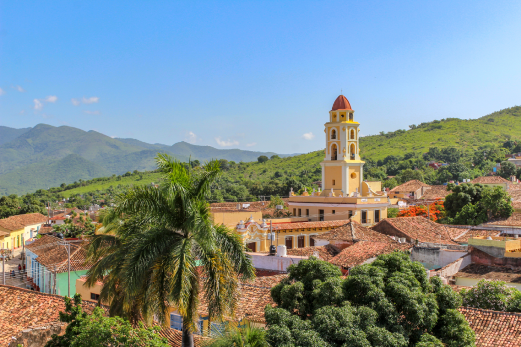
Cuba is a place that we hear so much about. Warm sun, tropical beaches, and gorgeous architecture in any one of its cities.
For all its faults and societal problems, it has earned its reputation as a tropical paradise in the sun.
This island nation sits directly on the equator and very close to the United States of America, which has definitely influenced foreign relations between the former and the latter.
However, when we think about Cuba compared to the US, what do we think about its size?
Sure, the US is big, as are a lot of countries in the Americas, but does that mean Cuba is big as well? Or is it really a small island?
Cuba’s Size And Landscape
Cuba is an island that has a total area of around 110,860 square kilometers or about 42,800 square miles.
This makes it the eighth-largest island country in the world, being ever so slightly bigger than Iceland and quite a bit smaller than the next largest, the United Kingdom, while being the seventeenth largest island overall.
The country of Cuba encompasses the island of Cuba and several much smaller islands around it, like the Isla de la Juventud – which is the second-largest Cuban controlled island and the 7th largest island in the West Indies.
Much of the terrain of Cuba is actually pretty flat plateaus that gradually turn into rolling hills, with only the coastal regions having mountains.
The main mountain range of Cuba would be in the south-east region, known as The Sierra Maestra Mountain range.
This mountain range surrounds the city of Santiago de Cuba with the tallest mountain on the Cuban island, Pico Turquino, being on the south-western part of the range with a height of 1,999 meters.
While there are other mountain ranges in the south-east, central, and western regions, they do not come close to this area for size or grandeur.
The island itself has very few natural occurring springs or water sources within its borders, which obviously is a bit of a problem for the country.
The largest natural lake is Laguna de Leche in the central Ciego De Ávila province and the largest man-made reservoir is the Zaza Reservoir in the Sancti Spiritus just a little north.
While Cuba does have the longest river in the Caribbean flowing through it, the Cauto River, it only flows through 3 very southern provinces, rather than the whole country.
At 230 miles long, this river is a lifeline for those provinces, though.
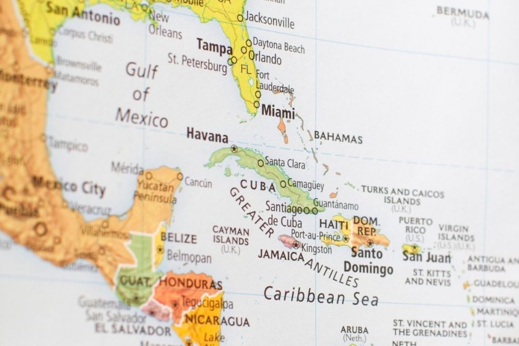
Where Is Cuba?
Cuba is in the Caribbean, just off the coast of North and South America, and it is the largest island within the Caribbean, as well as being the eighth-largest island nation in the world.
Within the Caribbean, Cuba sits just slightly north of the center of the sea itself.
It is 48 miles west of Haiti (through the Windward Passage), 13 miles south of the Bahamas and 93 miles south of Florida, 130 miles east of Mexico, and 87 miles north of Jamaica.
It should be noted that while it is 93 miles south of Florida, this is only to the Florida Keys, the island chain off the coast of Florida. The distance to mainland Florida is closer to 103 miles.
The position of Cuba so close to the different areas of the Americas has always made it a place of importance.
The original inhabitants of Cuba were the Taino and Guanahatabey people, who maintained a monopoly over the islands until the arrival of the European powers.
When Cuba was conquered by the Spanish, they used it as a secure stronghold and supply station to maintain their control over their colonies in the New World, as well as being a sugar plantation hub with many of the population being slaves.
This led to Havana becoming the third-largest city in the Americas for a long period of time, and Cuba’s importance to the Spanish Empire would remain until the Spanish-American War, which saw Cuba become a protectorate of the United States.
This would continue until 1959, when Fidel Castro led an uprising that brought the country under his control.
Even if Cuba is no longer part of or a tropical playground for different empires, its position and size have meant that it is still hugely important to the Caribbean and geopolitics as a whole.
Climate Of Cuba
The whole of the Cuba territorial area sits just south of the Tropic of Cancer, which is a longitudinal line that circumnavigates the globe.
This means that the local Cuban climate is a tropical one that only changes slightly with the north-eastern moving trade winds that blow across the island year-round.
The waters around Cuba are also subject to the Caribbean current as well, which flows throughout the Caribbean and warm the waters around the island with warm water from the equator.
The average climate of Cuba could be compared to that of Hong Kong, though Hong Kong is slightly colder than Cuba.
The average temperature of Cuba is 23 degrees Celsius during its coldest month of January and 27 degrees during its warmest month of July, meaning year round the entire island is incredibly warm.
Like a lot of countries that have tropical savanna climates, Cuba has a drier season between November and April and a wetter season between May and October.
This wetter season is also known as Hurricane season, as the Caribbean is prone to a lot of hurricanes occurring during this time.
This is due to the warm waters of the Caribbean mixing with the cold condensation of the air, creating a vacuum that turns into a hurricane.
Conclusion
Cuba is a large island and the largest island in the Caribbean, being about 110,860 square kilometers. This has made it an important geopolitical and trade island for much of the Americas ever since human beings first colonized it.
Although it has some interesting quirks of climate, geography, and area size, it is truly a tropical paradise worth seeing.

Once I got here, I fell in love. The buildings, the beaches, the monuments - I was in awe. I went on a different sightseeing walk every single day and never got bored of the city, which I had found to be a common issue while traveling through other places.
It just made sense for me to stick around in Havana from then on out. I never had the urge to keep backpacking, and I certainly didn’t want to return home to Utah now that I had seen this.
So, if you’re thinking of visiting Havana, stick around and learn more about the city from my website. Who knows, maybe I’ll see you out here!
- What Is The Largest Island In Cuba? - September 19, 2022
- Havana – Why Is It Cuba’s Most Exciting City? - September 19, 2022
- Cheapest Time To Visit Cuba (Ultimate Guide) - September 19, 2022


")


")